
You don’t need a weatherman
To know which way the wind blows
--Bob Dylan
In his 1965 stream-of-consciousness counterculture rap song, Subterranean Homesick Blues, Bob Dylan suggests if you pay attention to what’s going on around you, you don’t need an expert to explain it. All too often, however, your eyes and ears don’t give you the whole story. Sometimes an expert—in this case, a weatherman–is needed to protect you from what is not obvious.
Experienced sailors know and understand the value of a trained and experienced meteorologist. Prudent sailors vigilantly watch the seas and skies and search the horizons for current and potential weather conditions before and during a cruise. These sailors also closely monitor modern weather-watching devices, radio stations and weather services. Dylan was talking about navigating turbulent cultural and political times; sailors navigate turbulent weather and waters.
The Journey
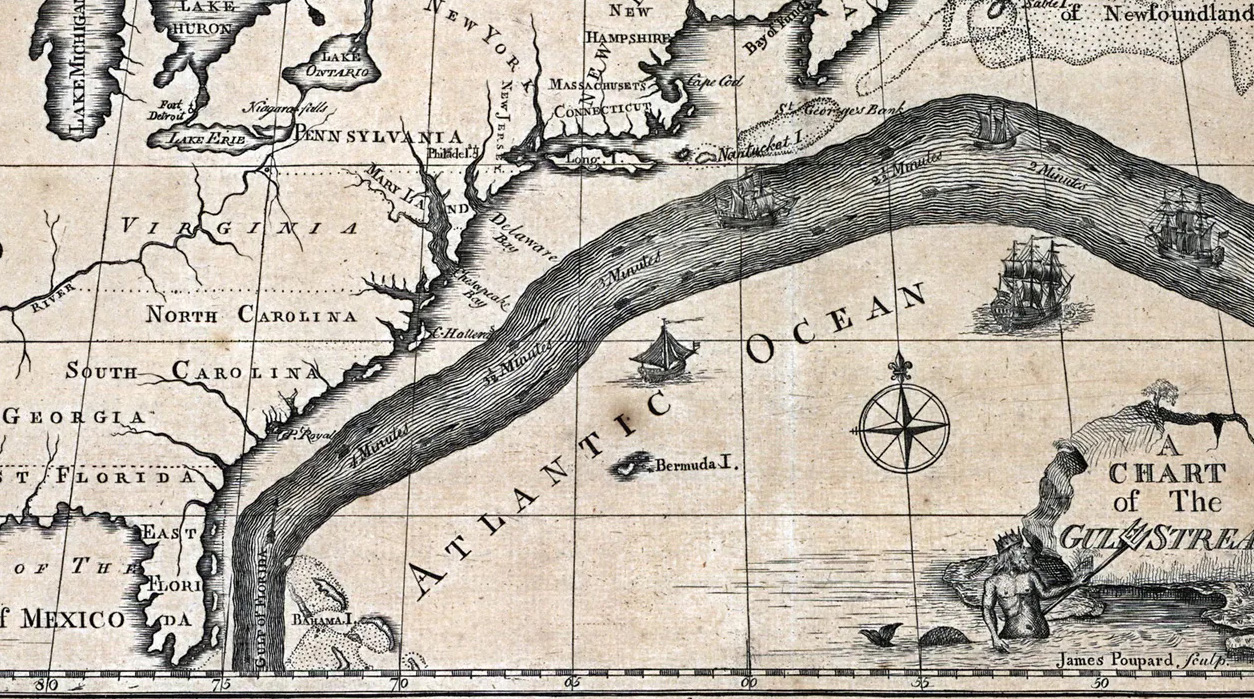
Five months and over 1,600 nautical miles (1,840 statute miles) after cruising out of St. Margaret’s Bay in Nova Scotia, Julie and I—and our sailing buddies Kerri-Ann and Howard on the other Gaviidae (henceforth Gaviidae 37)–were finally crossing from Florida to The Bahama Islands. Cruising on a sailboat to the Bahamas is not a simple matter of sailing south along the east coast of Florida, then veering left willy-nilly. The Gulf Stream—called a “a river of water in the Atlantic Ocean” —separates the Bahamas from Florida.
Florida’s east coast is typical of the Atlantic shore of the United States south of New York. Inlets are scattered, sometimes 30 to 80 nautical miles apart, and are of varying reliability; many are manmade or otherwise require frequent dredging and local knowledge.
Tides and Currents
Awareness of tides and currents as well as weather conditions is essential for safe passage in most of the inlets if you are on a boat with a substantial keel. Our sailing yacht Gaviidae requires 5 1/2-feet of water; we reluctantly enter calm passages less than 8 feet deep at low tide. With a maximum hull speed of 8 knots (8 nautical miles an hour) and an average speed of 6 knots, it takes us a while to travel long distances. The Intracoastal Waterway (ICW) along the southeast coast was built as a safe, reliable alternative to offshore passage; we used it for most of the journey south of Norfolk, VA to Riviera Beach, FL, just north of Palm Beach.
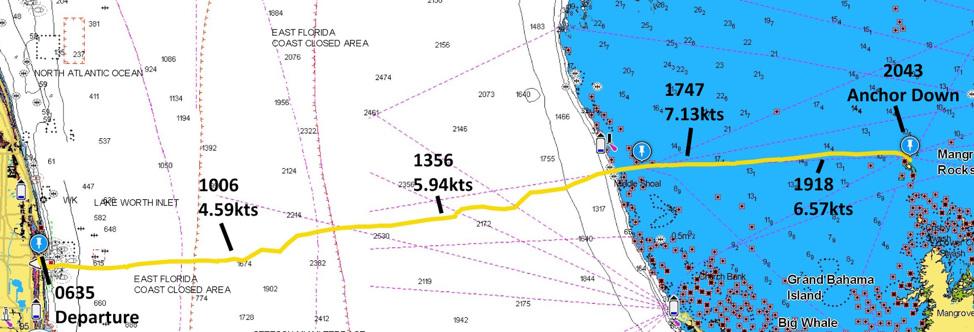
Riviera Beach/West Palm Beach (near the Lake Worth Inlet) are popular gathering spots and the primary jump-off point for boaters making the 60-mile voyage to the Bahamas. The Lake Worth Inlet offers the shortest access to the population centers of Freeport and Nassau, and the popular Abaco Islands via the remote inlet at Memory Rock, 15 nm north of Freeport. The western boundaries of the Bahamas features shoals, coral reefs and boat-threatening rocks. Besides the usual tempestuous surface conditions caused by tides and waves on the ocean, the Gulf Stream flows northward at 2-to-4 knots. For a slow-moving boat, that’s a 10-hour journey across a fast-moving current. The main strategy for boating from Florida to the Bahamas is to get well south on the east coast of Florida and chart a course that factors in that northerly current.
Weather and the Gulf Stream
That river of water presents its own unique challenges. The criteria required for a safe and comfortable crossing to the islands include no rain or thunderstorms and moderate winds blowing anywhere from the southeast to the west. Clear skies and cooperative winds offer what is known among sailors as a “weather window.” Avoiding storms is a no-brainer, but contrary winds present a different problem for boaters on the Gulf Stream: They can adversely affect the sea state.
Northerly and east winds can generate cross seas, aka, squared seas or square waves. When wind and currents running one direction meet wind or other currents coming from a different direction, the colliding water stirs up the surface creating high waves and rip tides. Weather fronts can generate cross seas in open water just about anywhere. Cross seas create an uncomfortable and, potentially, dangerous ride. Ideally, the Gulf Stream and any winds flow together in a northerly direction. The strength and duration of north winds can disrupt the Gulf Stream so much that it can take days to settle down after the winds have dissipated.
Chris Parker – The Weatherman
Forewarned about needing good weather and sea conditions, we subscribed to meteorologist Chris Parker’s Marine Weather Center (MWC) in mid-January. Parker is an avid sailor and meteorologist specializing in environmental conditions from the Gulf of Mexico and the Caribbean Sea north along the eastern seaboard of the United States. The MWC team provides weather and routing information tailored to cruisers on smaller (generally 30-65 ft.) sailing and motoring vessels.
As we traveled south through northern Florida along the ICW, we considered cruising immediately to the West Palm/Riviera Beach area to await a favorable weather window. Reports that marinas there were very expensive, and local anchorages were full of boaters also waiting to cross the Gulf Stream quickly killed that notion. We knew of one 30-boat flotilla parked in the area waiting to cross. We opted to stay in an inexpensive mooring field 35 miles north of Riviera Beach at Jensen Beach, FL. It was a wise decision. We waited nearly 3 weeks for a suitable weather window. When we got notice of a favorable weather window from Chris Parker, we cruised down the ICW to the Havn Yacht Club Marina in Palm Beach Shores.
Julie: A Mon27 crossing still looks good. There are still some factors to consider. First an elongated RIDGE near 30N Today relaxes NE winds before gradient comes more variable from NE-ESE and falls to 12k or less late tonight. Models suggest a very slim risk of a N land breeze up to 10k along the immediate coast at Dawn but most areas are NE-ESE and under 12k and stay either L&V or E backing NE or NNE under 10k the rest of the day.
Forecast excerpt from weatherman Chris Parker
FORECAST:
7AM depart LakeWorth: L&V or N-E-ESE under 12k; Seas 1-3′ chop and 2-4’/7-9secNE-ENE swell; Dry.
11AM EXIT GS near 26-50N/79-20W: L&V or NE-ENE under 10k; Seas 0-2′ chop and 1-3’/7-9secNE-ENE swell; Dry.
2-3PM near Memory Rock or just S of Memory Rock 26-52N/79-07W: L&V or NE under 10k; Seas 0-2′ chop; Dry.
6-7PM near Great Sale Cay in Mangrov Cay: L&V or N-NE under 10k; Seas 0-2’/5-8secN-E; Dry
Last Minute Preparations
Havn is just half a mile north of the Lake Worth Inlet and offers diesel, fresh water and a place to do laundry. All last-minute amenities needed before departing Florida. We topped off our main fuel tank, our reserve tank and filled two five-gallon Gerry cans for a total of 70 gallons. We now had enough for 60-to-70 hours of motoring. Gaviidae burns about 1 gallon of diesel per hour cruising at about 6 knots and 2,100 rpms on our 71-horsepower engine. We were looking at over 150 nautical miles to the next fueling opportunity—potentially motoring all the way. Our expected fuel consumption was 25 gallons.
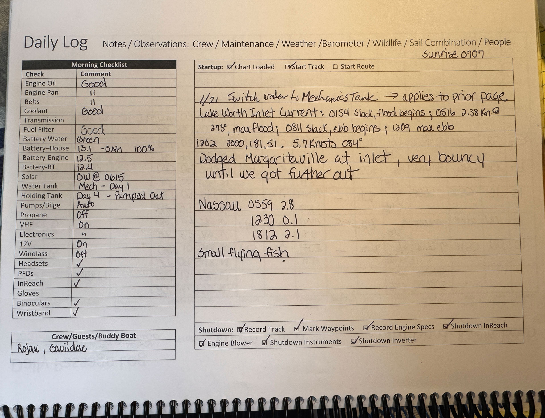
Sunrise was 0707, the agreed-upon time to rendezvous with Gaviidae 37 and a local couple we met a few days earlier who were joining us for the crossing aboard their sailboat, Rojax. Julie and I were up in the predawn darkness for final preparations and departure at first light. It usually takes us about an hour for last-minute systems checks on the boat and make tea/coffee necessary for the days journey. We look at engine oil and coolant levels as well as water levels in our flooded battery house bank. We examine engine belts for tension, wear and tear and look for signs of leaks or other anomalies in the pan below the engine. All this information is logged into our logbook. Already armed with routing, tidal and current information, we look at last-minute weather updates and download routing details to our passage and tracking devices.
Scramble to the Start
About 0620 Julie got a text message: Our buddy boats had upped anchor and were heading to the inlet. A full half-hour before what we thought was our agreed-upon time. Gaviidae 37 and Rojax were anchored on the other side of the inlet. The night before Rojax swung by Gaviidae 37 in their dinghy and indicated they would be raising anchor at 0630. Since we had been doing most of the communication with Rojax, Howard assumed we were aware of the change. When he saw that we weren’t moving, he sent the text message. Fortunately, our systems checks were completed and logged when we got word they were underway. We immediately scrambled to disconnect shore power, fire up the engine and undo dock lines. It was a calm, clear morning but barely light. I backed Gaviidae out of the slip—keeping an eye on the dock pilings behind us—while Julie coiled dock lines and the shore power cord and secured our fenders.
Steaming along as quickly and as safely possible in the slowly gathering morning light we got to the inlet in just a few minutes. Searching on AIS, the Automatic Identifications System used for vessel tracking, we located our sailing buddies well down the Lake Worth Inlet on our chart plotter. Then we heard a radio warning an unnamed sailing vessel that they were in the path of Margaritaville, an incoming passenger cruise ship. Our friends were in their way. Monitoring Margaritaville’s speed and direction via their AIS broadcast, we quickly navigated out the narrow channel well to starboard to avoid the incoming ship captain’s ire.
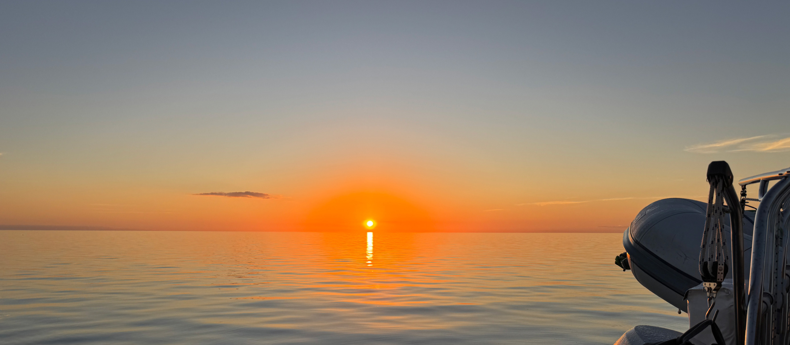
We cleared the channel and Margaritaville just as the sun peaked over the horizon.
Lumpy Ride
We immediately encountered choppy, confused seas churned up by 11-knot wind out of the east as predicted by weatherman Chris Parker. The custom forecast suggested winds “might” move more southeast as the day progressed (see Parker report excerpt). With our engine running at 2,200 rpm, our speed over ground (SOG) was a little over 5½ knots—almost a whole knot less than we would be doing in calmer water. We were off to a rough start, and I put on my electric anti-seasickness wristband. We immediately deployed our staysail to help stabilize the boat in the rough seas as we bounced along through the turbulent water. As the morning progressed the winds edged northeasterly maintaining 11-to-14-knots.
About 7 nm offshore we unfurled our mainsail as we entered the main—and most powerful—part of the Gulf Stream. We set a course for east by southeast to help offset the northerly push of the Gulf current. That attack also gave us a more favorable close-hauled sail with the main and the staysail deployed to take advantage of that persistent northeast wind. The seas settled down when we hit the actual northerly stream, but we were crawling along at 4½ knots. We had powered down the engine to deploy the mainsail, then settled in at 2,000 rpm to help push us along. With a planned route of 80 nm at less than 5 knots per hour, the day was shaping up to be a long slog.
Fickle Wind
The wind never gave up its northeast orientation, but we were pushing 5½ knots about noon and hit 6 knots by early afternoon by keeping 30 degrees off the wind. By 1500 (3:00 p.m.), we were cruising along at 6½ knots boosted by the engine at 2,200 rpm. We entered the Little Bahamas Bank at Memory Rock a couple hours later, ahead of our buddy boats.
With another 3 hours to our day’s destination at Mangrove Cay some 20 nm due east, we furled the staysail and pushed the diesel to 2,300 rpm. Sometime around sunset we pulled the mainsail in. We motored along at 7 knots in the relative calm of the Little Bahama Bank, which averages 14 feet in depth throughout. The place name, “Bahama,” is thought to have been derived from what indigenous Taino people called the island of Grand Bahama; “large upper middle island.” A popular belief is that the name comes from baja mar, Spanish meaning “shallow sea.”
Anchoring in the Dark
As we neared Mangrove Cay, we received word that Rojax was experiencing engine problems. Our friends on Gaviidae 37 offered to turn back to help, but the crew of Rojax waved them off and were underway in a couple hours. We arrived at Mangrove Cay a little after 2000 (8 p.m.) and anchored off the uninhabited island’s east side. When we arrived, there was at least one boat anchored west of the cay and a trawler on the east side with us. Gaviidae 37 and Rojax dropped anchors west of Mangrove when they arrived sometime later.
Day Two – Alternate Route
We weighed anchor at dawn the next morning after reviewing Parker’s forecast and made for Crab Cay—about 35 nm to the east. Normally, sailors head from Mangrove Cay to Great Sale Cay, another uninhabited island 23 nm northeast. Navionics and AquaMaps, the digital charting services we use, showed well-marked “preferred” routes that way. Julie found a route in the Cruising Guide to Abaco Bahamas that went east across Little Bahama Bank that would shave an hour off the cruise via a more direct route to Crab Cay. The route was not marked on our digital Navionics chart and included some stretches through shallow water. Gaviidae 37 and Rojax opted for the more familiar route.
Tue28 morning depart Mangrov: L&V or W-NW under 10k<NW@8-12g15k; Seas 1-3’/4-7secW-NW; Dry.
2nd Day forecast from weatherman, Chris Parker
Tue28 afternoon-evening arrive in Crab Cay: NW@10-15g18k; Seas 1-3’/5-8secNW chop and 1-3’/7-10secE swell Dry.
Tue28 night in Crab Cay: NW@8-15<L&V or NW-NE under 10k; Seas 1-3′<0-2’/5-8secNW-NE; Dry.
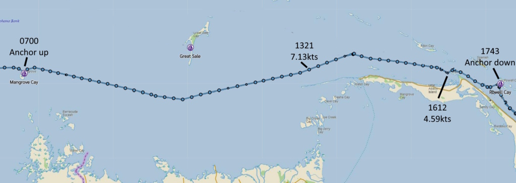
With favorable winds and weather, we motorsailed with the mainsail across the newfound shortcut and arrived at Crab Cay at 1400, well ahead of the other two boats. We never saw anything less than 10 feet of water, but I still went forward to watch for coral heads anytime depths went below 12 feet. When we arrived, we determined that the anchorage offered no shelter from already-building west-northwest winds that could make for an uncomfortable night. We considered heading back west six miles to an anchorage called Pensacola-Allans Cay, but decided we didn’t want to backtrack. We continued east to Powell Cay—another 8 nm.

We arrived at Powell Cay at 1700. A sailing catamaran was already parked there off its south shore. It’s a big bay with plenty of room to drop our hook well out of the northwest winds. By 1745, the anchor was down, the instruments turned off, and adult beverages in hand!
Day Three
Up early the next morning, we saw Gaviidae 37 heading down the channel. After a few short text exchanges, we learned they were told to arrive before 1100. This was to avoid running aground in the entrance channel at low tide. We quickly weighed anchor and followed in their path. When we reached our destination—Donny’s Marina—we had logged 157 nm in three days. Gaviidae 37 was already tied up at Donny’s T-dock. We learned later that Rojax had pulled into another bay on Green Turtle Cay. That was the last we heard of them.
Despite Bob Dylan’s misgivings, our weatherman, Chris Parker, had gotten us to the Bahamas safe and sound.
January 27, 2025 – January 29, 2025 26°45.507’N 077°19.367’W 2799.4 Nautical Miles