
I’ve been busy working on our 2017 Float Plan that will start in Rhode Island and take us into the Great Lakes in time to get to Lake Michigan early July. There are a number of options that would get us from salt water to fresh. Our current plan is to go to New York City, take a right up the Hudson River, then cut across New York state via the Erie Canal. Other options include:
- Sail south around Florida, then west across the Gulf and north up the Mississippi River—all right turns, like UPS. Besides taking most of the summer doing this route and slogging up the Mississippi, the real gotcha is the 100-mile portage of 24,000lb boat from Minneapolis to Duluth.
- Sail north and get into the Great Lakes via the St. Lawrence Seaway – not practical (ever hear of paddling upstream?) unless we can be a dinghy behind one of the Salties heading west.
- Trucking – um, it’s a boat.
- Head up the Hudson, Erie and Oswego canals, and cruise across Lake Ontario to either the Welland Canal around Niagara Falls and into Lake Erie or the Trent-Severin Canal into Lake Huron’s Georgian Bay. Not completely ruled out but we expect to explore Lake Ontario in a future summer.
That last option is what a lot of people would do—maybe even most. As for us – well, we’ve never been good at following the norm.
I busily started working on the float plan. I surrounded myself with the New York State Canal System Cruising Guide, Skipper Bob’s Cruising Guide, notes from the Great Lakes Cruising Club, Richardson’s Hudson River & Adjacent Waterways chart book, and of course my trusty iPad with the Navionics charting app that I would use to actually build the route.
Did I really need all that info? Yup. While there is some overlap, each resource provides information not found in another. No one source entirely covers all we need to know to safely enjoy our cruise on the canals. For example, the Canal System Cruising Guide is the essential source for the locks and distances but it does not cover whether a place you might want to stop has a wall free of spikes or other hazards that could impale people or boats. Or where you can drop your mast and raise it on the other end of the journey. It also shows no depths. The boat draws 5-feet, 6-inches of water. To be safe, we need at least 6 feet of water – depth is kinda important. Richardson’s is the best guide to depths, but it doesn’t cover the west end of the canal!
Skipper Bob’s reveals where we can find ice cream, but offers scant detail on depths. On the other hand, Skipper Bob’s does warn where shoaling has been reported in recent years. Bob’s also points out lift bridges that share one operator, which may result in time-chewing delays while the operator shuttles from lift bridge to another. This information can be critical when you’re trying to figure out whether you’re going to make last call for Happy Hour at the next stop.
I’ve now spent the better part of two-days just working on the Erie Canal portion of our float plan. I’m still not done because of a series of snags and dilemmas cropping up as I cheerfully charted out my plan on the iPad.
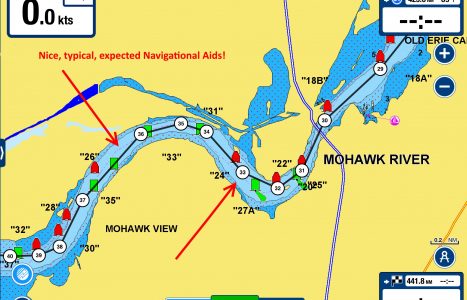
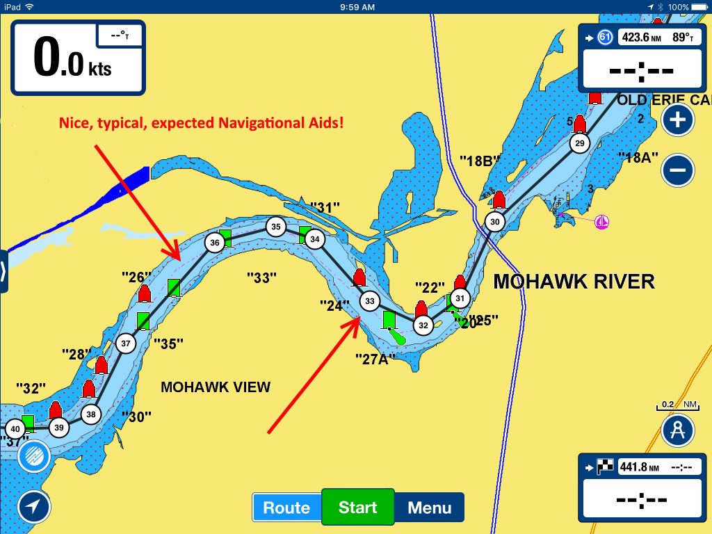
The first issue was when my electronic chart no longer showed any navigational aids. So, I started adding “Pins” for various bridges so I could keep track of where I was in relation to the paper charts and the electronic chart.
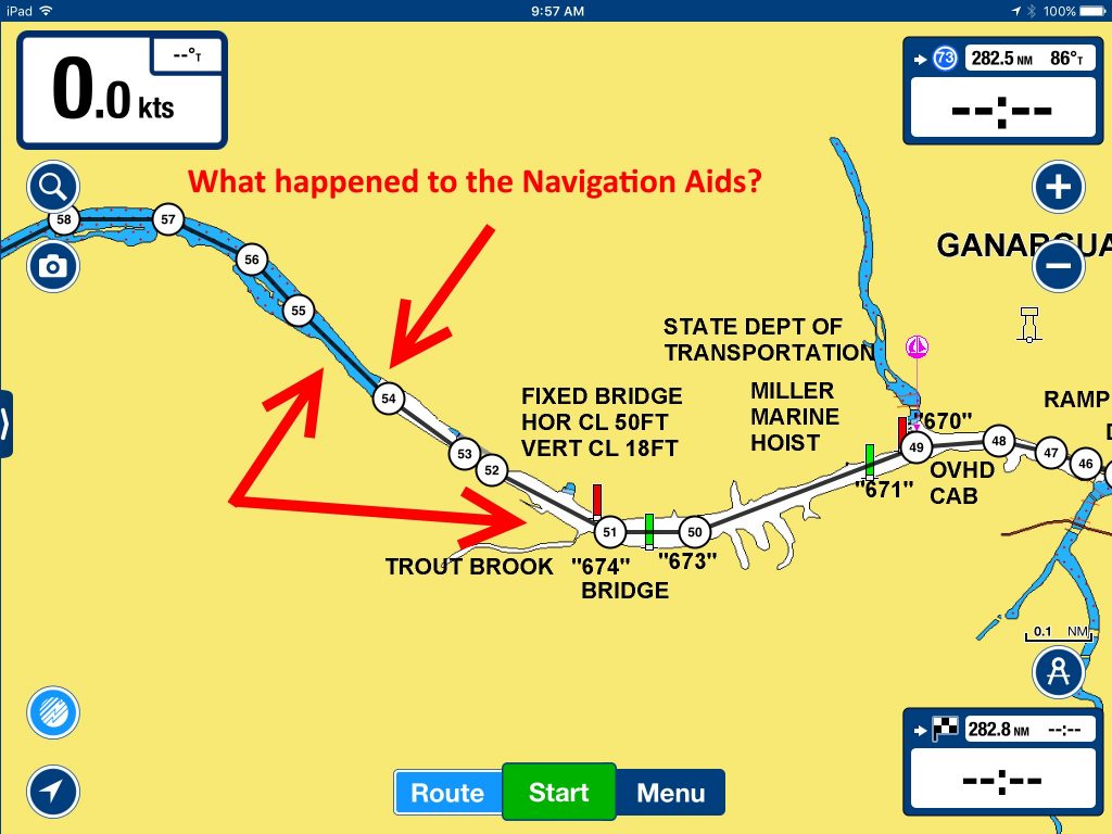
Then I ran out of water. Literally. My first reaction was that I was zoomed in too close and took a wrong turn. Nope. I was definitely on the right waterway but the electronic version of my chart has us going across land.
Yikes! I’m pretty sure the Navionics system doesn’t predate October 26, 1825—when the Erie Canal was completed. I really hope it’s just a coding error and that we don’t have to portage the damn boat after all.
Julie,
Angele and I went up the Erie Canal in 2005,with our boat we draw six feet. very pleasant trip. Lots of improvements for docking, most towns have good docks. The one caveat is the spring thaw it can cause flooding along the Mohawk river portion of the canal. It stops all travel. Check it out with the canal authority. The canal goes through the snow belt of New York. Once past the Mohawk it is very comfortable. Many place to tie up, the canal is the back side to many towns so the stores tend to be a bit of a walk. Traveling with the mast on deck makes the boat a 50 footer for handling. You have to anticipate a little more when going into the locks.
Give us a call if you want to discuss it more. By the way I single handed the boat for about 80 miles of the canal.
Jim Passe
Thanks Jim – we’re hoping any flooding will be done by the time we are heading through. Worst case scenario – we don’t make it to the GLCC Rendezvous in Sturgeon Bay!
Remember Julie you have LOTS of current on the Mississippi also and if your going that way wby wouldn’t you go thru Chicago?? Paper might be better in some of those canal areas. Du
You are so right Captain! But I think we’ll stick with figuring out the Erie Canal! We’re going to be a motorboat for 350+ miles – putt, putt, putt.
We find that Active Captain is one of the richest sources of information for cruise planning. Lots of crowd sourced info.
Thanks Cricket – we’ve not used Active Captain much because there is very little use of it on Lake Superior or where we were sailing in the North Channel on Lake Huron. Since we’re going to be on more populated waterways this summer, we’ll have to start checking it out.